Sidia is a education Platform website.


Monetary Economics | MN25C
Matakuliah ini merupakan kajian tentang konsep dasar ekonomi moneter yang di dalamnya mengkaji Bank sentral dan otoritas Jasa keuangan, Bank umum, lembaga keuangan non bank,
Monetary Economics | MN25A
Matakuliah ini merupakan kajian tentang konsep dasar ekonomi moneter yang di dalamnya mengkaji Bank sentral dan otoritas Jasa keuangan, Bank umum, lembaga keuangan non bank,
Monetary Economics | MN25B
Matakuliah ini merupakan kajian tentang konsep dasar ekonomi moneter yang di dalamnya mengkaji Bank sentral dan otoritas Jasa keuangan, Bank umum, lembaga keuangan non bank,
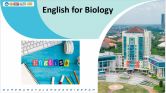
English FOR Biology | 2025B
This course discusses reading, listening, speaking, writing, and paragraph development in English with biological substances. The material is delivered with a student-centered approach in practical
Metodologi Penelitian Biologi | 2024E
The Research Methodology course discusses the nature of research, objectives, characteristics of quantitative and qualitative research that are relevant to biological research and equips students
Metodologi Penelitian Biologi | 2024D
The Research Methodology course discusses the nature of research, objectives, characteristics of quantitative and qualitative research that are relevant to biological research and equips students
Copyright © 2026 Sinau Digital UNESA All Rights Reserved